
LUBBOCK, Texas — KAMC Meteorologist Ron Roberts has your Friday evening forecast. Sponsored by J Ferg Pros.
Tonight: Severe Storms, low of 53°. Winds out of the SE, 10-20 MPH.
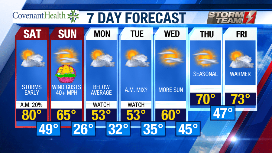
Tomorrow: Partly cloudy, high of 80°.Winds out of the SW 15-25 MPH
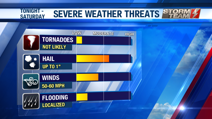
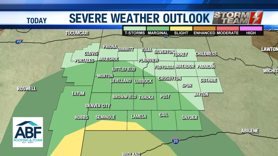
Isolated severe storms will remain possible across the region during the overnight hours tonight. The primary threats will be damaging winds in excess of 60 MPH, and hail up to the size of golf balls (1.75″).
Areas to the southeast of Lubbock have the greatest potential to see severe storms.
The possibility of severe storms will last through the overnight hours, on into Saturday morning. Overnight lows will fall onto the middle and lower 50s. Winds will be out of the southeast around 10-15 MPH.
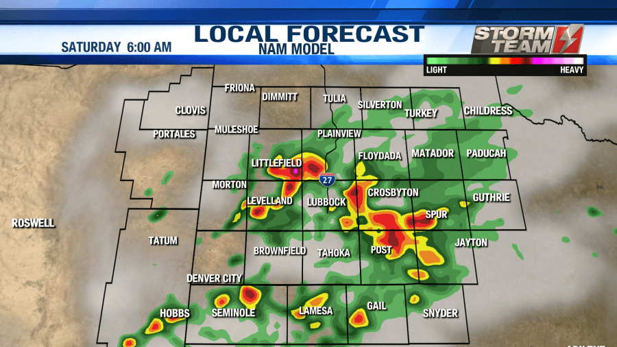
Strong to severe storms will remain over portions of the region until around 2 PM on Saturday. The best chance for severe storms will remain to the east of Lubbock. Damaging winds and large hail will continue to remain the main threats.
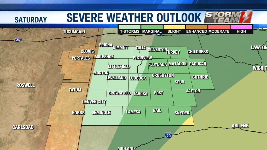
As a cold front moves into the area, clouds will begin to give way to a mostly sunny sky. Winds will be out of the southwest around 15-20 MPH. Highs will top out in the upper 70s and lower 80s. Rainfall totals will vary quite a bit across the region. If you get caught under one of the stronger storms, totals could approach 1-2 inches. Conditions will calm down Saturday night as lows fall into the upper 40s and lower 50s.
A significant surge of colder air will arrive for Easter Sunday! Highs will fall below average for Sunday, only topping out in the middle 60s. Winds will be howling out of the northwest, gusting close to 50 MPH at times. Blowing dust will be possible across the region. Travel may be difficult for tractor trailers along I-27. We will see a mostly clear sky throughout the day. As we head into the overnight hours, clouds will gradually increase across the region as our next weather maker moves closer to the area. Lows will be significantly colder, with a freeze possible across most of the area. Lows will fall into the middle 20s and lower 30s by Monday morning.
Throughout the day on Monday, clouds will gradually begin to increase as our next weather system approaches from the northwest. Highs will be well below average, only topping out in the middle and lower 50s. Winds will be out of the east around 12-18 MPH. This will help bring in some more moisture to the South Plains. As we head into the overnight hours, temperatures will fall back close to freezing. As this happens, precipitation will begin to move in from the northwest. Once the precipitation starts to fall, it could transition into a rain/snow mix by early Tuesday morning.


Models still aren’t in 100% agreement with this system, and the exact storm track remains unknown. Just know there is the possibility of some minor accumulation on grassy and elevated surfaces early Tuesday morning. By Tuesday afternoon, temperatures will return to the lower and middle 50s, so impacts will not be long lived. Winds on Tuesday will be out of the southeast around 10-15 MPH, helping to bring in some warmer air. Tuesday night, lows will hover in the middle to lower 30s.
Temperatures will warm through the middle 60s, into the middle 70s by next weekend, with more sunshine returning to the area.
Have a wonderful weekend! Please remain weather aware tonight.
-Ron
Facebook: Ron Roberts KAMC
Twitter: RonRoberts.TV


