
LUBBOCK, Texas — KAMC Meteorologist Ron Roberts has your Thursday evening forecast. Sponsored by J Ferg Pros.
Tonight: Partly cloudy, low of 45°. Winds out of the ESE, 10-20 MPH.
Tomorrow: Mostly cloudy, high of 65°.Winds out of the SE 15-25 MPH.
As we head into the overnight hours tonight, clouds will remain around the region. Isolated showers will be possible early, especially across the Permian Basin. Lows will fall into the lower 40s to lower 50s, with winds out of the east-southeast around 12-18 MPH.
For your Good Friday, high temperatures will remain below average. We will top out in the middle to upper 60s across the region under a partly to mostly cloudy sky. Showers and storms will begin to develop later during the afternoon and evening hours.
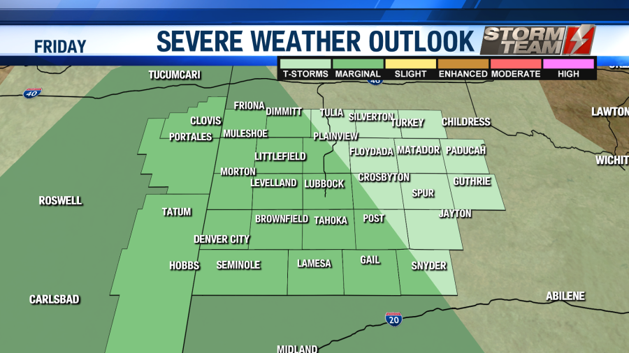
Storms will initiate along a dry-line. Some of the storms could have damaging hail and winds associated with them. A level 1 marginal risk of severe storms has been issued for portions of the area, mainly to the south and west of I-27. This does include the city of Lubbock.
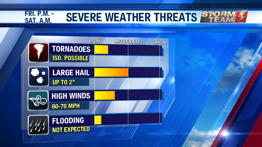
As we head into the overnight hours, scattered storms will remain possible. These storms will continue to pose a severe threat for damaging winds and large hail. Tornadoes are not likely, but they cannot be completely ruled out. Overnight lows will remain mild, only falling into the lower and middle 50s. Winds will remain breezy out of the south, gusting close to 30 MPH at times.

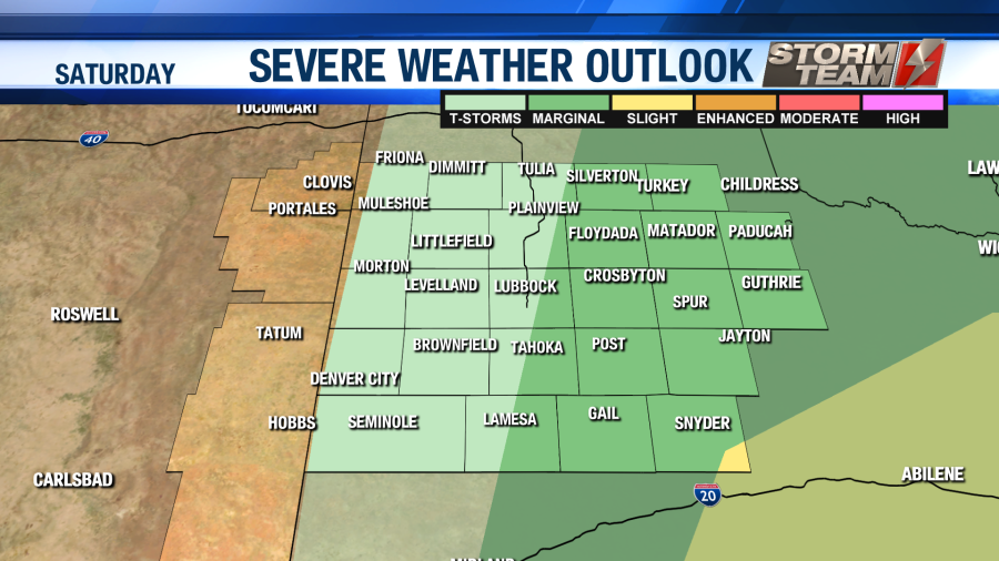
Showers and storms will remain possible on Saturday, with the best chance of severe storms to the south and east of Lubbock. A level 2 slight risk has been issued for portions of the area. The main threats on Saturday will continue to be damaging hail and winds.
High temperatures will be a little warmer, resulting in a bit more energy for storms. Highs will warm into the middle and upper 70s under a partly cloudy sky. Winds could gust as high as 40 MPH outside of thunderstorms, possibly resulting in some blowing dust. As we head into the overnight hours on Saturday, we will see a clearing sky across the area with lows dipping into the upper 40s to middle 50s.
Easter Sunday will be a nice and sunny day. Highs will be a bit cooler thanks to the passage of our cold front. We will top out in the upper 60s and lower 70s under a mostly sunny sky. Winds will gust up to 30 MPH at times out of the north-northwest. Overnight lows will plummet, with most locations falling into the upper 20s and lower 30s.
A weak trough will move into the area Monday into Tuesday. This system has the potential to bring some precipitation to the region. It appears this precipitation will be on the light side. Highs on Monday and Tuesday will be well below average, only topping out in the lower to middle 50s. Monday night into Tuesday morning, lows will fall back close to freezing. This is the same time that precipitation is expected to move into the region. This could result in a light wintry mix over portions of the region. Accumulation of any type is not anticipated at this time. We will definitely keep you advised on this system.
For the remainder of the week, highs will slowly begin to warm into the middle 60s, to the middle 70s by next weekend. It appears that we will remain dry as well.

Have a fantastic Friday, and be sure to practice social distancing!
-Ron
Facebook: Ron Roberts KAMC
Twitter: RonRoberts.TV