LUBBOCK, Texas — KAMC Meteorologist Jacob Riley has your Saturday evening forecast. Sponsored by J Ferg Pros.
Tonight: Partly cloudy, low of 60°. Winds from the S 10-20 MPH.
Tomorrow: Severe storms, high of 88°. Winds out of the SE, 20-30 MPH.
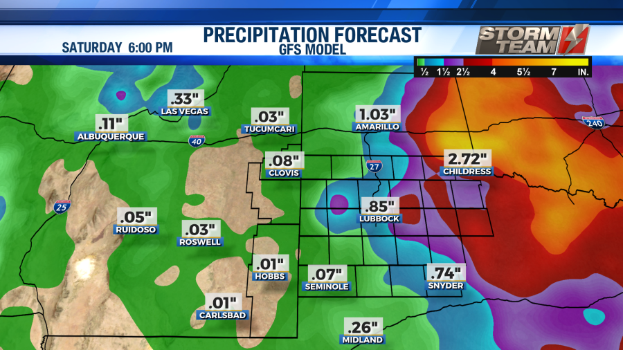
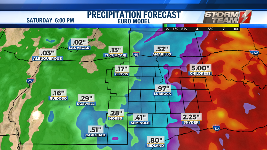
This afternoon, showers and storms are expected to move through the South Plains. A Level 2 Slight risk for severe storms has been issued for areas to the east of the 87/I-27 corridor. Damaging winds close to 70 MPH, large hail up to 3″ in diameter, isolated tornadoes and localized flooding will all be possible. Storms will develop during the late afternoon and early evening hours near the 87/I-27 corridor. Storms will move to the east. All activity should come to an end by midnight tonight. Low temperatures will dip into the upper 50s and lower 60s under a partly cloudy sky overnight. Winds will remain out of the south around 12-18 MPH.


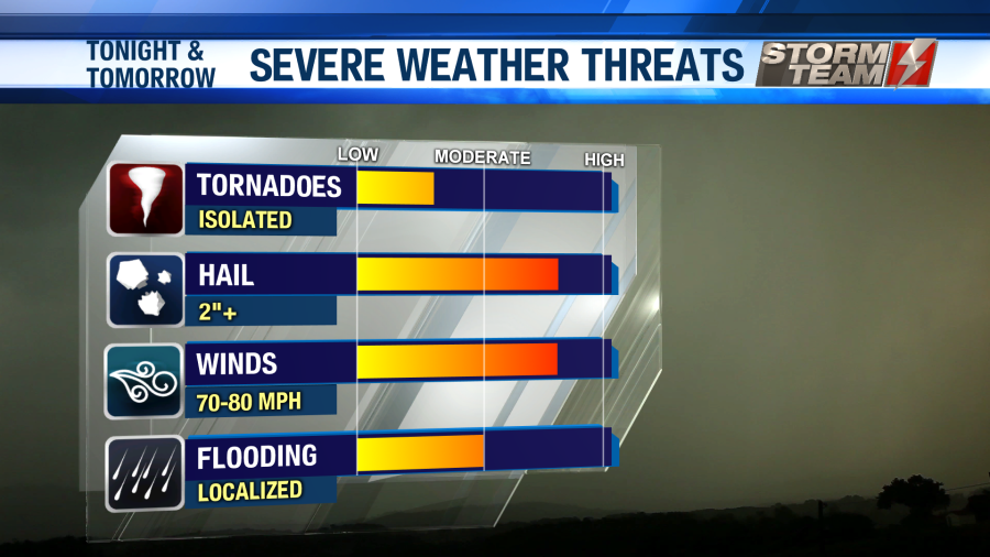
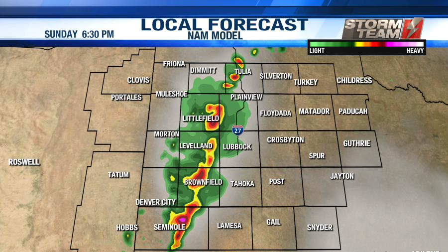
For your Sunday, severe storms will be possible once again. More of the South Plains will be included in the Level 2 Slight risk for Sunday. Once again, damaging winds close to 70 MPH, large hail up to 3″ in diameter, isolated tornadoes and localized flooding will all be possible. Storms will develop near the Texas-New Mexico state line by mid to late afternoon. All severe activity should come to an end by midnight Sunday night. As we head into Monday morning, we will likely see a few showers hang around the region. Low temperatures will fall into the middle and upper 50s under a partly to mostly cloudy sky.

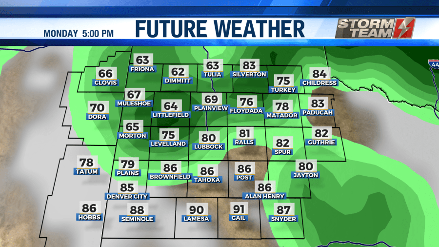
Widespread showers and storms will be possible on Monday. A cold front will move through the region during the day. This will result in high temperatures remaining in the lower to middle 70s. Some locations may not make it out of the upper 60s. As of now, it looks like we will not have to deal with any severe weather on Monday. Just a nice, steady rain across the South Plains with an occasional rumble of thunder or two. Winds will shift from the southeast to the northeast behind the cold front. Overnight, winds will remain out of the northeast around 10-15 MPH as lows dip into the upper 40s to lower 50s.
For the remainder of the week next week, showers and storms will remain in the forecast during the afternoon and evening hours. A low pressure system will move into the region early Tuesday morning, and begin to stall out. Since the storm system is not expected to move much, it will bring us several rounds of rainfall. This is great news for our ag-producers, and it truly couldn’t come at a better time. Some areas may see as much as 2 inches of rainfall!
High temperatures will remain in the 70s to lower 80s all week thanks to the increased precipitation chances and cloud cover. Overnight lows will remain in the 50s to lower 60s.

Have a great Memorial Day weekend, and please stay weather aware!
-Jacob.
Facebook: Meteorologist Jacob Riley
Twitter: @jrileywx