
LUBBOCK, Texas — KAMC Meteorologist Jacob Riley has your Sunday evening forecast. Sponsored by J Ferg Pros.
TONIGHT: As we head into the late evening hours tonight through the early morning hours of Monday, winds will remain breezy out of the west. Winds will gust close to 25 MPH at times overnight. These winds combined with increasing cloud coverage will result in morning lows temperatures in the middle to upper 40s across the region! That is about 20 degrees above average for this time of year.
MONDAY: Temperatures on Monday will be much cooler for a few reasons. One, we will be under a mostly cloudy sky throughout the entirety of the day. Two, as we head into the afternoon hours, showers will begin to move into the region. The best chance of rain will remain south of Highway 82. Isolated sprinkles will be possible north of Highway 82. During the afternoon hours, we will also have a cold front begin to move into the region from the north. Before it arrives, high temperatures will top out in the middle to upper 50s across the area. Northern portions of the Permian Basin could pick up close to 0.50″ of rainfall on Monday. Once the cold front passes through, it will allow temperatures to fall into the middle and lower 30s overnight, with a few upper 20s possible. As temperatures fall below freezing, some lingering precipitation will still be present over portions of the South Plains. This could allow for a brief transition over to a wintry mix or a light snow.

No major snow accumulations are expected at this time. Ground temperatures will be far too warm, and wintry precipitation will only occur for a short period of time. Areas to the south and west of Highway 84 will have the greatest potential to see a few flakes early Tuesday morning, particularly between Midnight and 6 AM.

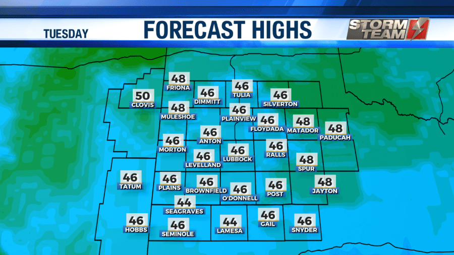
TUESDAY: Tuesday will be much cooler across the South Plains. High temperatures will peak in the middle to upper 40s across the region. Any leftover precipitation will come to an end by noon on Tuesday. During the afternoon hours, we will begin to see clouds taper off, leaving us with a partly cloudy sky. Overnight, we will clear out across the region, allowing for morning lows to drop into the upper 20s and lower 30s by Wednesday morning.
WEDNESDAY & THURSDAY: Another weak trough will move into west Texas and eastern New Mexico Wednesday into Thursday. This will help keep our temperatures a little on the cool side. We will see a partly to mostly sunny sky across the area both days, with high temperatures in the middle 50s. Winds will be out of the south-southwest around 8-12 MPH both days. Overnight lows on both nights will fall into the middle and lower 30s.
FRIDAY & SATURDAY: Above average temperatures will return to the area as we head into the weekend. Daytime highs will top out in the lower 60s. It will be a wonderful start to the weekend! We will see a mostly sunny sky across the area, with a warm westerly wind gusting close to 20 MPH at times. Overnight lows will remain above average, falling into the lower 30s Friday night and the lower 40s on Saturday night.
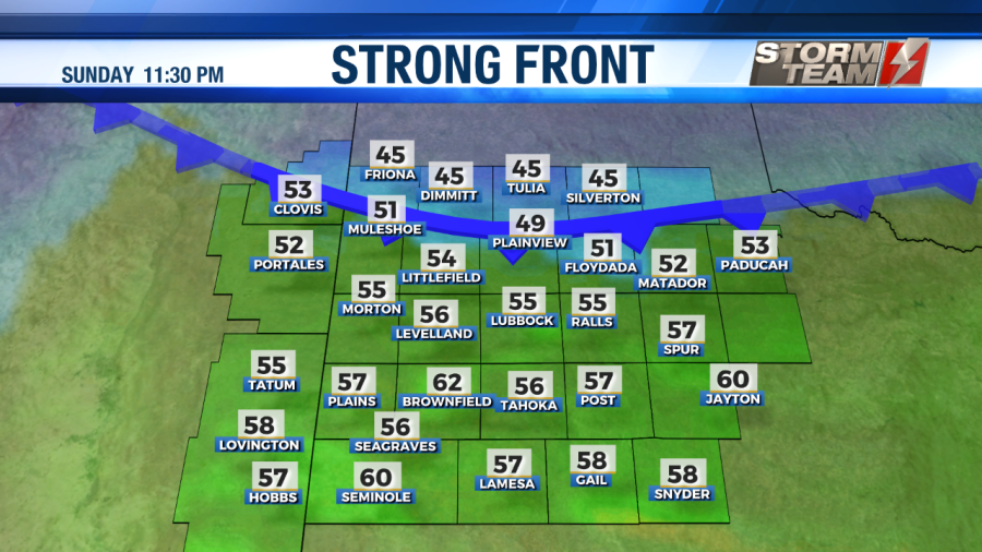
SUNDAY: A strong front will move into the Texas panhandle on Sunday. Ahead of the front, we will warm into the middle and upper 60s across the South Plains. Winds will be breezy out of the southwest, gusting close to 30 MPH at times. Once the cold front passes through, temperatures will plummet. Overnight lows will fall into the middle and upper 20s.
Have a wonderful week!
-Jacob
Facebook: Meteorologist Jacob Riley
Twitter: @jrileywx
This video was updated at 11:14 PM to add the forecast video.


